Posts Tagged ‘aerial photographs’
Drone Views
Despite some gusty winds on Sunday, there was an opportunity to view our property from overhead via a drone. I find this a spectacular variation of our perspective of the immediate surroundings we traverse every day. Much better than simply viewing a dramatically more distant 2-dimensional image from a satellite photo.
Let’s take a little tour, starting at the house…

That’s a lot different view from all the shots of the house we’ve tried taking from down below in the backyard.
Down the hill and through the short corridor of trees we come to the labyrinth.
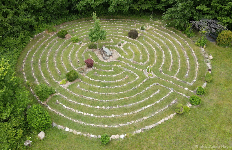
If you are careful to spot the 180° turns, you can walk the path with your eyes. Imagine the sounds of the breeze in the trees, the calls of songbirds, and maybe the sound of horses grazing in the back pasture.

I was pleased to see the drone didn’t startle the horses but Mix certainly took notice and circled the herd around once for good measure. Then they all went back to grazing.
Back up the hill of the backyard and past the house, we come to the shop and garage.
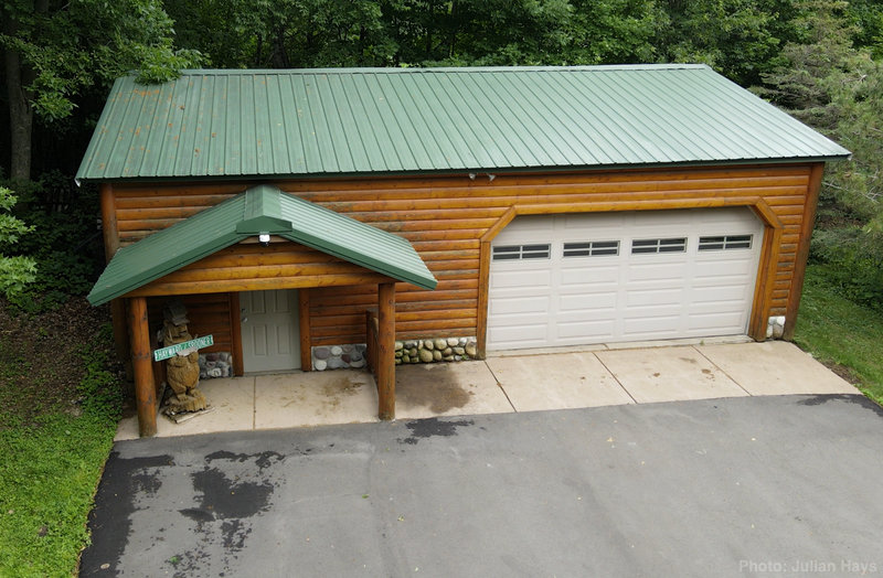
The amount of equipment squeezed inside is a mystery with the doors closed.
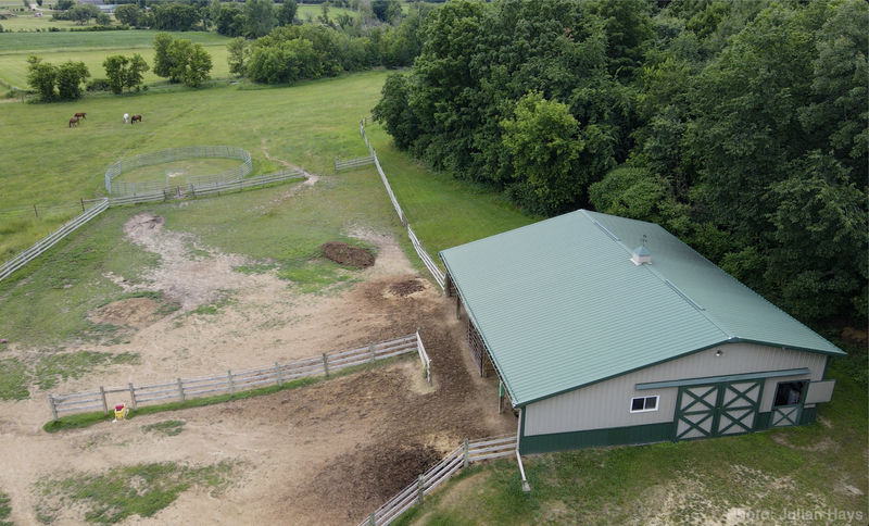
Finally, the drone was steered out for a brief glimpse of the barn before the dwindling battery brought the exercise to a safe conclusion.
The trees are so full of leaves that it made it difficult to capture a low-angle view that revealed the proximity of each feature in relation to the others.
We spent some time trying to fly down one of the paths in the woods but the drone was reluctant to follow commands smoothly due to the detection of nearby trees and low-hanging branches.
It was a thrill for me to watch the process and I treasure the views that we captured. Makes me want to have a jet pack that would let me quickly pop up for a similar view whenever the higher perspective seems warranted.
Maybe Greenworks will come up with a battery-powered one soon.
.
.
Thrown Back
The other day I was hunting for the U of MN site that offered access to a library of historic aerial images and found several different views of the farm my grandfather bought back in the early 1950s. (https://apps.lib.umn.edu/mhapo/) That property was called “Intervale Ranch” and the name became the inspiration for our choosing “Wintervale” for the land where Cyndie and I now live.
My family was living there when I was born in 1959. The farming was mostly done by then and the barns and nearby surroundings became a large playground for my siblings and me.
Looking at the various images I found of that land has thrown me back into years I recall fondly. The weather I experienced for the first ten years of my life seemed like a reliable and relatively consistent pattern of seasonal transitions. For all I knew, that’s the way it had always been and would always be.
Hah! Ten years out of the incomprehensible span of time from the forming of planets to the human-influenced environment of Earth we are experiencing today. I expect the naiveté of youth is why that time of my life seems so envious now.
In the most recent ten years we have experienced increasing instances of rainfall during winter months (instead of snow) to the extent it is no longer a bizarre occasion.
I was also thrown back to fond memories of the media commonly on in our home. There were a mere five channels of broadcast television to watch. Walter Cronkite on the national news. Dave Moore on the local station. Boone & Erickson on the radio. If you wanted to know if school was closed due to a snowstorm, you listened to WCCO radio. After they gave the ag reports, they’d read the alphabetical list of communities with school districts that were closed or running two hours late.
On my transistor radio in my bedroom I would tune in KDWB or WDGY to hear the latest hits of popular music.
We moved from the house on that property to a neighborhood of around twenty houses when I was ten years old. It was my first exposure to the fact that the world wasn’t as static my young perspective believed.
Slowly, but surely, television changed, personalities came and went, and I grew into my teenage angst.
In a way, nothing holds a candle to the first ten years of my life for the bliss of being surrounded by my family on the remnants of that farm near the border of Eden Prairie and Edina in Hennepin County, Minnesota, U.S.A.
.
.
Aerial View
We were finishing breakfast yesterday morning when our friend, Mike Wilkus, texted that he and his niece would be flying over our place in twenty minutes. Cyndie responded that we would be out in our field with the horses and asked for a photo of the labyrinth. Right on time, we heard the sound of a small plane approaching.
They flew right over us and made a turn to come around again. It was easiest for us to see them when they were right over us but from my experience as a passenger in small planes, I knew it is most difficult to see what is directly below. It felt a little dorky to be waving my arms broadly toward a small visible speck of a plane so far away in the sky, but I was guessing that was when they would have the best-angled view of us.
Soon, Mike was sending us pictures he took and Cyndie was sending hers right back. It went a little like this:
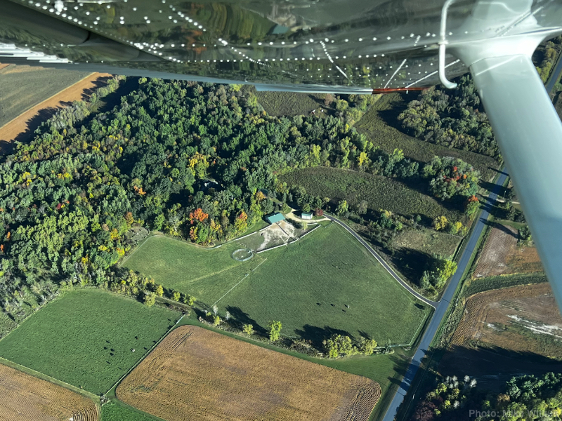


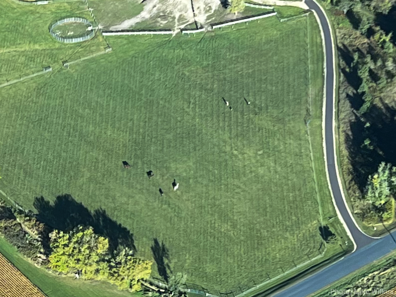
The four horses stand out pretty well in that last image. Cyndie, Delilah and I were a little above and to the right of the horses. To the right of us, the bottom portion of our brand spanking new driveway stands out rather nicely, too. Looks pretty good even from that altitude.
.
.
Aerial History
With much appreciation to my son, Julian, for his pointer to a precious University of Minnesota online historical aerial photograph resource he stumbled onto yesterday, I dedicate today’s post to my siblings and cousins who will most likely enjoy this more than anyone else.
I immediately searched for images from my old Eden Prairie homes. I started looking at our house on Cedar Ridge Road, but the big fun was exploring views of Intervale Ranch on old County Road 18.
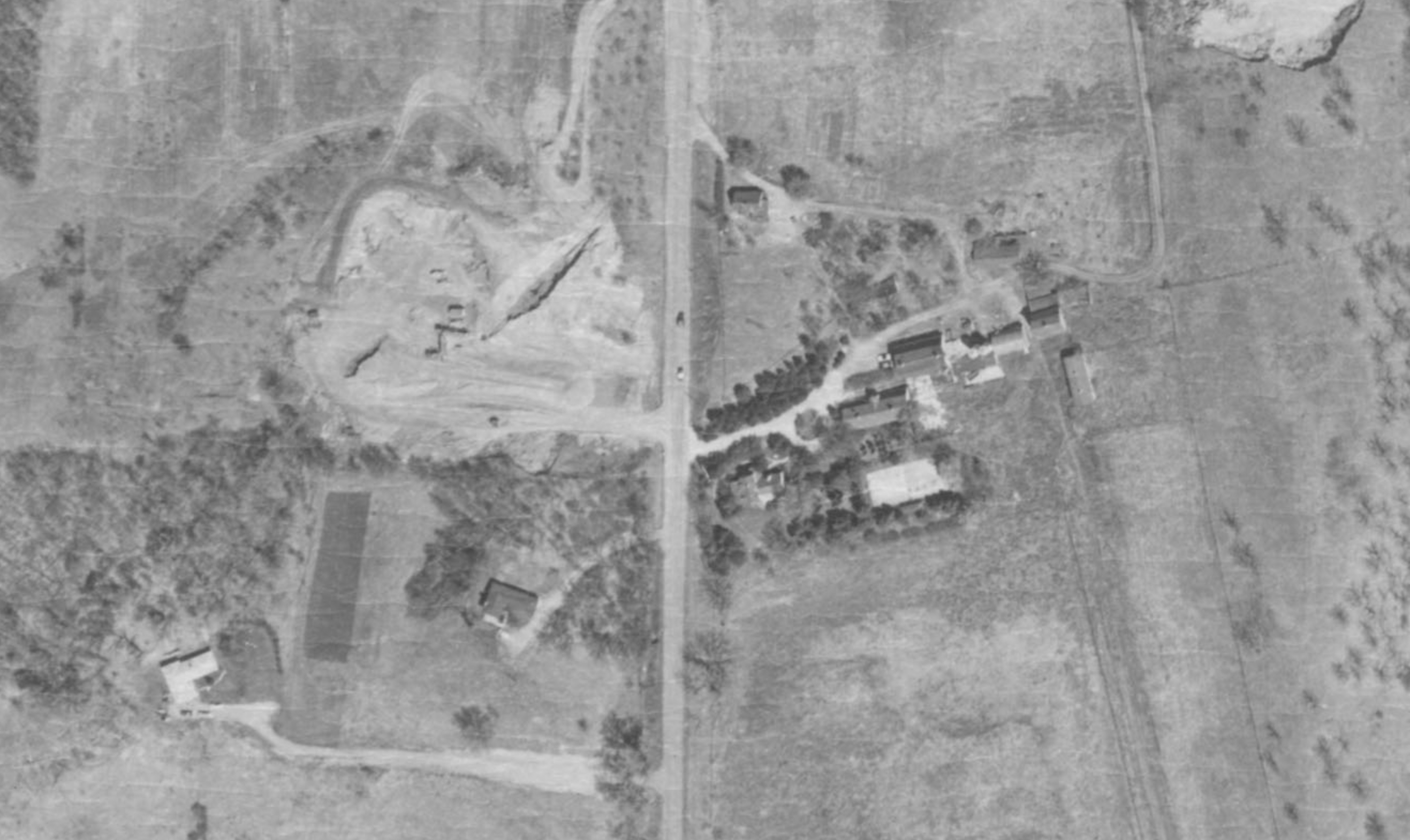
Check out the place in 1960:
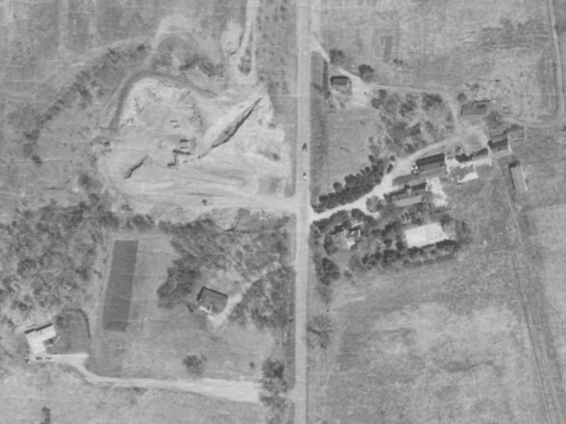
I have cropped this to include Fullerton’s and McCartney’s houses for reference, and the gravel pit across from the driveway of our house.
You can clearly see the center circle of our driveway, the tennis court, the barns, and the house on the hill that was the Superintendent’s quarters where the family first lived while our grandparents were in the main house.
Just seven years later, it looked like this:
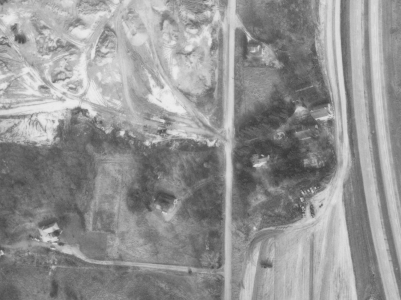
Look how much bigger the gravel pit is. You can see the divided highway that formed the barrier between us and Braemar Park. I’m pretty certain that the final excavation of the surroundings was already underway, based on the pathway cleared between the outer barn and the highway.
Here is a closer zoom focusing on Intervale:

Can you find the chestnut tree?
And finally, here is a wider pan to show more of the surroundings:

This gives the added reference of 494 in the bottom of the frame, much of the golf course, and –with the stark white roof– the Braemar hockey rink.
You can also see the rest of the expanded gravel pit.
Remember how hilly it was around there? From the satellite view, it is really hard to get a sense of those dramatic features. I believe we have photos of the construction of the north/south divided highway that was County 18 at the time that are dated 1962. I find it interesting to consider the changes that happened in the seven years between these images.
Cyndie and I have been at Wintervale for seven years now. In October it will reach eight. Luckily, I’ve already been collecting the overhead satellite views of this property.
Hopefully, there won’t be any divided highway installations coming into the pictures in our lifetimes.
.
.


