Aerial History
With much appreciation to my son, Julian, for his pointer to a precious University of Minnesota online historical aerial photograph resource he stumbled onto yesterday, I dedicate today’s post to my siblings and cousins who will most likely enjoy this more than anyone else.
I immediately searched for images from my old Eden Prairie homes. I started looking at our house on Cedar Ridge Road, but the big fun was exploring views of Intervale Ranch on old County Road 18.
Check out the place in 1960:
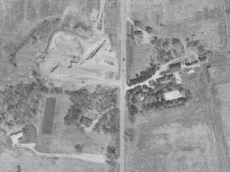
I have cropped this to include Fullerton’s and McCartney’s houses for reference, and the gravel pit across from the driveway of our house.
You can clearly see the center circle of our driveway, the tennis court, the barns, and the house on the hill that was the Superintendent’s quarters where the family first lived while our grandparents were in the main house.
Just seven years later, it looked like this:
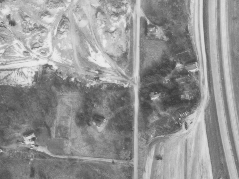
Look how much bigger the gravel pit is. You can see the divided highway that formed the barrier between us and Braemar Park. I’m pretty certain that the final excavation of the surroundings was already underway, based on the pathway cleared between the outer barn and the highway.
Here is a closer zoom focusing on Intervale:

Can you find the chestnut tree?
And finally, here is a wider pan to show more of the surroundings:

This gives the added reference of 494 in the bottom of the frame, much of the golf course, and –with the stark white roof– the Braemar hockey rink.
You can also see the rest of the expanded gravel pit.
Remember how hilly it was around there? From the satellite view, it is really hard to get a sense of those dramatic features. I believe we have photos of the construction of the north/south divided highway that was County 18 at the time that are dated 1962. I find it interesting to consider the changes that happened in the seven years between these images.
Cyndie and I have been at Wintervale for seven years now. In October it will reach eight. Luckily, I’ve already been collecting the overhead satellite views of this property.
Hopefully, there won’t be any divided highway installations coming into the pictures in our lifetimes.
.
.


It said my comment couldn’t post, so I’m trying again. Please remove if a duplicate🤷♀️
Wow! Really cool! I sure don’t remember those structures beyond the big barn, but I was able to wander through the rest of the property in my mind. When you talk of hilly, made me think of the “million” steps up the hill to the Roper’s house…
Such great growing up memories!
Mary
July 7, 2020 at 7:49 am
Got your comment this time (and only once). This UofM site is a treasure trove of memories.
johnwhays
July 7, 2020 at 7:35 pm
Thanks John and Julian! What a wonderful memory to explore. I keep trying to zoom in more or want to wonder through a ‘street view’! Too many choices to pick the chestnut tree…….An amazing place to have grown up❤️
Judy
July 7, 2020 at 7:35 am
Isn’t that fun? You should check out that site and explore other places of interest.
johnwhays
July 7, 2020 at 7:34 pm